Views on the upgrade of Dalian street lamp geographic information system

In recent years, the construction of street lamps in Dalian has been changing with each passing day, from the simple lighting function to becoming an important part of beautifying the urban environment and improving the urban investment environment. With the rapid development of information technology and the expansion of the city scale, the existing streetlight geographic information system in our department can not meet the current management needs in terms of system software, business management software or regional integrity. It is urgent to adopt more advanced Computer information technology and digital management tools to enhance the existing street lighting geographic information system. First, achieve the following objectives: (1) Synchronize with the urban development to improve the basic electronic map of street lamps; (2) Adapt to improve the street lamp management database, increase the functions that the existing system can not achieve; (3) Spatial information and attribute information for various resources Quickly query, retrieve, count, and analyze, and provide accurate data for planning, construction, and maintenance of street lighting facilities; (4) Produce thematic maps and draw output according to any attribute conditions, in various ways such as lists, graphs, and charts. Output the result of the operation. Second, the technical measures for system upgrade: (1) The current world-class software Arclnfo is used as the GIS platform. The platform integrates many existing mainstream technologies, adopts COM component technology and object-oriented secondary development environment: provides long transaction processing and version management; adopts the openness and management mode of commercial database RDBMS, so that the urban cadastral management information system always maintains technology. The leading position. (2) Data management using the world's most recognized large-scale database SQLServer to support the growing load demand, providing the reliability, scalability, security and ease of use necessary to run GIS massive data. Sexually, adequately protect and reasonably store system data and access information efficiently. (3) Access GIS data through the Spatial Database Engine (SDE) to provide spatial data services for any supported client application, manage large geographic elements in a continuous, seamless data, and provide high efficiency for spatial and non-spatial data Operating database service. (4) Resource sharing, information sharing, all source code is open, and we are free to expand and redevelop. At the same time, in terms of system environment selection, in view of the existing platform of our company is the desktop map information system launched by Mapinfo Company in the United States in 1986, the graphic data of this product does not contain topological structure, and its mapping and spatial analysis capabilities are relatively weak. The ratio of performance to price is far less than the Arclnfo software system developed by the US Environmental Systems Research Institute (ESRl). The author believes that the Arcinfo platform should be adopted, because the platform has the following salient features: 1. Adopt a geographically-relational data model to support the vector and raster representation of geographic objects. 2. Provides strong space operation and analysis capabilities. 3. Modular structure, flexible and easy to expand. 4. Provide the ArcObiects component library, which contains more than 1,100 separate COM components. Supporting secondary development of the system, it can develop the functions of almost all professional geographic information systems. 5. Provides 38 map projection methods for coordinate conversion between projections. 6. Develop the foreground system program interface with the excellent professional development tool VisualBasic programming environment to ensure the system program interface is beautiful and easy to operate. 7. With the ability to store and manage large data volumes, large commercial relational databases are used to store and manage data, and several large geographic information system projects have been built to date. 8. A developmental architecture that provides an interface to connect directly to multiple databases. 9. It has good compatibility and can be converted to and from 25 different system data formats for system integration with other data formats. 10. Independent of hardware, supporting the widest range of hardware platforms. 11. Provide a very convenient user interface, users can call the program of this system, the application outside the system and the resources of the operating system. 12. Broad support for today's various industry standards, including operating systems, graphical user interfaces, commercial databases, network protocol standards, spatial data exchange formats, and graphical output formats. Third, the principle of system upgrade: (1) Practicality: fully consider the specific situation of our office, the developed system can be integrated into the actual work of various departments and positions, so that it can play its due role in the work, the system interface is friendly Easy to operate, easy to manage and maintain. (2) Standardization: Includes standardization of development processes and standardization of data coding. It is fully developed in accordance with the industry standards for software development, classifying and coding data according to existing environmental protection national standards and industry standards, and formulating local standards suitable for the system according to the characteristics of environmental protection units. (3) Accuracy: In GIS system, the most important and most difficult is the collection and maintenance of information data (including graphic data and attribute data). The system expresses real, real-time, accurate and reliable data, which is the guarantee of vitality of GIS system. . (4) Sharing: The system's data and resources are shared to ensure the uniqueness and consistency of the data. (5) Security: The system has complete and strict authority division, and all departments and positions are authorized. jobs. The system data has a complete backup mechanism. (6) Scalability: With the continuous expansion of our business scope, business volume, usage department and users, the system has good scalability in terms of functions, processing power, data capacity and number of users. Also consider the connectivity of the system to other systems. (7) Advancement: Fully adopt the latest technology of GIS development, consider the development trend of environmental protection business, adopt advanced and reliable GIS platform, database platform and system development tools. Fourth, the implementation of wireless monitoring system and geographic information system integration. Geographic Information System (GIS) is a computer technology system that provides geographic and dynamic geographic information and geography research and geographic decision making based on geospatial database. It focuses on the display and management of different map layers. By combining the monitoring system with the geographic information system, the status information of the monitoring can be obtained in real time and the geographical position of the object can be accurately obtained on the electronic map, so that the monitor can obtain an intuitive understanding and understanding of the state of the monitored object, which is convenient for controlled Management of target real-time information.


1

 Multilayer PCB

Multilayer PCB consist of 3 or more circuit layers bonded together by a thickness of insulating material called prepreg and core. They came into the industry with the advent of SMD population. They are found almost everywhere, wherever electronics are in use – from aircraft to motorcycles, and storage power stations to photovoltaics.

Multilayer PCBs are most complicated than others, and are generally considered to be the most sophisticated PCB product due to their construction methods and design complexities.

BentePCB offers multilayer printed circuit boards with the following special technologies:

·  Edge plating for shielding and ground connection

 Â·  High frequency base materials for applications up to 80 GHz

 Â·  Cavities, countersunk holes or depth milling

 Â·  Thick copper up to 105μm (inner and outer layers)

 Â·  500μm thick copper inlays using HSMtec technology

·  Solder resist in green, white, black, blue, grey, brown, etc.

·  Controlled impedances (single, differential, etc.)

·  All recognised Printed Circuit Board industry surfaces available


Items

Manufacturing Capabilities

Number of Layers

1-16 layers

Material

FR-4

Maximum PCB Size(Dimension)

650x1200 mm

Board Size Tolerance(Outline)

±0.2mm/±0.5mm

Board Thickness

0.6-3.0mm

Board Thickness Tolerance(t≥1.0mm)

±10%

Board Thickness Tolerance(t<1.0mm)

±0.1mm

Min Trace

0.1mm/4mil

Min Spacing

Outer Layer Copper Thickness

1oz/2oz/3oz/4oz(35μm/70μm/105μm/140μm)

Inner Layer Copper Thickness

1oz/2oz/3oz/4oz(35μm/70μm/105μm/140μm)

Drill Sizes (CNC)

0.2-6.3mm

Min Width of Annular Ring

0.15mm(6mil)

Finished Hole Diameter (CNC)

0.2mm-6.2mm

Finished Hole Size Tolerance(CNC)

±0.08mm

Solder Mask

LPI

Minimum Character Width(Legend)

0.15mm

Minimum Character Height (Legend)

0.8mm

Character Width to Height Ratio (Legend)

1:05

Minimum Diameter of Plated Half Holes

0.6mm

Surface Finishing

HASL with lead

HASL lead free

Immersion gold

Solder Mask

Green ,Red, Yellow, Blue, White ,Black

Silkscreen

White, Black, None

Panelization

V-scoring,

Tab-routing,

Tab-routing with Perforation (Stamp Holes)


About Us:

BentePCB is a professional PCB manufacturing which is focus on double side, multilayer, HDI PCB, rigid PCB and Flexible PCB mass production. The company was established on 2011.
We have two factories together, The factory in Shenzhen is specialized in small and middle volume orders and the factory in Jiangxi is for big volume.

Why Us?

UL (E492586), ISO9001,  ISO14001, TS16949, RoHS certified.
Turnover USD 
10-50 million per year.
15,000 sqm area, 450 staff .
Mass Production from single to 
16 layers.
Special Material:
ROGERS, Arlon, Taconic.etc.
Client:
Huawei, SAMSUNG, Malata, Midea,Texas Instruments.etc.


Certification(UL:E492586, TS16949, ISO14001, ISO9001,RoHS):

ISO9001,ISO14001UL:E492586

Factory Tour:

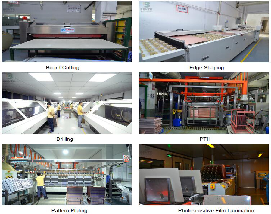
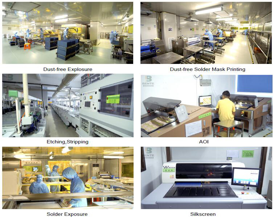
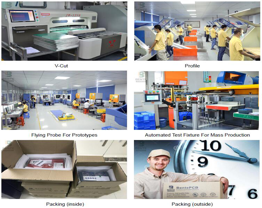
PCB Manufacturer

PCB Factory

PCB Manufacturing

Exhibition:

We Took part in the famous exhibitions over the past years,and got highly appreciation from the top experts,as well as cooperated tightly with them.

Exhibition

Delivery:

BentePCB offers flexible shipping methods for our customers, you may choose from one of the methods below.
Delivery

FAQ:

Q1: What does BentePCB need for a customized PCB order?
A: The customers need to provide Gerber or pcb file.If you do not have the file in the correct format, you can send all the details related to the products.
Q2: What is your quotation policy?
A: For the PCB order in large quantity, BentePCB will send you the quotation based on the MOQ of the products concerned, and the price will be reasonable with good quality.
Q3: How long will you send us quotation ?
A: After all files were sent, 2 to 8 hours as per your file.
Q4: What is your minimum order quantity?
A:Our MOQ is 1 PCS.
Q5: How about the service BentePCB offered to the customers?
A: If you have any questions about our products or company, do not hesitate to send us your inquiry to our customer service representatives, Your satisfaction is our pursuits.

PCB China

Contact Us

Multilayer PCB

Multilayer PCB, Multilayer PCB Design, Multilayer Circuit Board, Rigid Multilayer PCB

Shenzhen Bente Circuit Limited , http://www.bentegroup.com