The introduction of GIS technology in the field of security is not accidental. There are many connections between the two. Their combination will promote the development of the security industry to a greater extent. At the same time, it is also a good supplement and improvement to GIS itself. ..
Introduction to GIS technologyGIS Geographic Information System (GeographicInformaTIonSystem) is based on a geospatial database, supported by computer software and hardware, using system engineering and information science theory, scientific management and comprehensive analysis of geographic data with spatial connotation to provide management, decision-making and other institutions Information technology system.
In recent decades, GIS technology has developed rapidly, and its applications involve almost all fields. At present, it is mainly used in transportation, military public security, post and telecommunications, agriculture, forestry and animal husbandry, disaster prediction, land management, urban planning, resource survey, environmental assessment, Water conservancy and power, public facilities management, statistics, commercial finance, etc.
The main data comes from control measurement, digital photogrammetry, remote sensing, digitization and other methods. The main carrier and application methods are GIS server, PC client, PC stand-alone application, mobile PDA, tablet PC, smart phone, Web service, etc.
Computer technology is the foundation of GIS. GIS has been advancing with the development of computer technology. With the support of computer technology development and the drive of various new application requirements, GIS is being integrated into massive data management, efficient data processing and rendering, virtual reality (Augmented Reality), cloud services, mobile and other directions.
Industry application status
In recent years, with the development of society, various new application requirements have been proposed to the security field. At present, some monitoring platform software has used GIS for basic map browsing, business layer editing, element positioning, dynamic target monitoring, emergency command , Path planning, remote navigation, 3D scene video query, video retrieval, video playback and other functions, the application of GIS on the security monitoring platform has taken shape, but the combination of the two is not only from the perspective of breadth or depth, but also Not to a satisfactory level.
The main direction1. Geographic information management of security targets
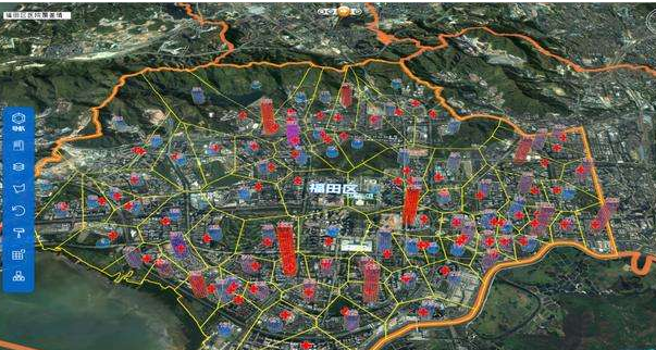
Incorporate video acquisition equipment, video storage equipment, servers, access control, alarm hosts, bayonet equipment, and monitoring targets into the geographic information system, establish exclusive vectorized business layers, and incorporate into the system's base map management, using GIS components can achieve the following basic Features:
Mark the monitoring equipment on the map, and specify the labeling style (symbol, color, size, icon, etc.) by the user;
Customizable layer prompt information, when the mouse is hovered over the target of the map element, the prompt information floating frame is displayed;
Add devices to the map layer by dragging and dropping from the device list or device library;
Accurately locate the device in the map with the latitude and longitude under the specified coordinate system, and order the positioning pattern such as flashing, etc .;
When the device alarms, it can also control the linkage of GIS map components through associated service management;
Map zoom in, zoom out, roaming, ranging, map printing, point selection, multi-selection (rectangular frame selection, polygonal selection, circular selection), query attributes (such as camera model, number and other customized information, etc.), etc., through the map The selected device or the right-click menu form can operate the device to perform actions (such as viewing real-time video, video playback, alarm arming and disarming, camera field of view analysis, and moving target track playback).
2. Mobile target monitoring
GIS maps are used to display information such as the location, direction, and speed of dynamically rendered moving targets in real time. Currently, they are mostly used for vehicle monitoring, personnel positioning, and remote navigation with mobile positioning equipment. The basic functions are as follows:
View the location and attribute description information of the target in real time in the map;
View multiple targets simultaneously on the map, or the map range moves with a single target;
Target track playback, by time range or by map range, etc .;
Watch the moving target video in real time;
Statistical calculation of the target mileage;
The target's stillness, movement, signal loss, target online and offline status alarm;
Target position alarm, such as path offset, near feature point, cross-border, etc .;
Use the GIS spatial analysis method to query the real-time video of the target appearing on a certain video channel or the video recording clip in a certain time period in combination with the time period conditions. At present, the query is only a simple area buffer method, and does not consider the camera's visual distance, azimuth, real-time status and other factors.
3. Assistant decision command
Use the analysis function of GIS for situation analysis and display, path selection, site selection planning, and resource allocation:
When responding to emergencies, quickly plan rescue routes, dispatch personnel, supplies, etc .;
Draw a situation map and demonstrate the combat plan. Use the graphical tools of GIS to draw a situation diagram to demonstrate the simulation of the battle plan;
Calculate and visualize the optimal path. Determine the composition of weights according to demand, investigate basic data (such as road length, capacity, real-time traffic conditions, etc.) and calculate weights, and construct a basic path network is the key.
Restrict bottleneck1. Security geographic information standard
For GIS application systems, the benefits of standardization are obvious, and without the guidance and constraints of standard specifications usually leads to many problems. First of all, data is the foundation of an information system. All applications are rooted in data. Spatial data is the foundation of GIS. Due to the particularity of spatial data, the spatial data in real situations often differ greatly in format, specification, and quality. This is not enough for GIS with high data quality requirements. To this end, the introduction of GIS in the field of security must determine the corresponding spatial data standards according to the application requirements to guide the industry data acquisition. Standards usually include specifications such as data acquisition channels, data storage, data exchange, element classification, and data scale. Secondly, the inconsistency of symbolization standards in the industry will greatly affect the user experience and increase the user's cost of use. Therefore, for industry map elements, there should be symbolization standards recognized in the industry. The purpose of GIS applications is to allow certain content related to time and space to be displayed in an intuitive manner. Visualization is one of the most important advantages of GIS, so unified Industry symbolization standards are essential. In addition, other content, such as the inconsistency of industry proper nouns, etc., will also lead to increased use costs and technical learning costs for users, system builders, and other relevant personnel. From the perspective of industry development, it is very unfavorable.
In recent years, the country has vigorously invested in the construction of a national basic geographic information platform, and has formulated a series of standards, based on the basic geographic information standards, for many GIS application industries (such as police geographic information systems, GPS navigation geographic information systems) The demand has produced various industry standards for geographic information, such as police geographic information standards and navigation geographic information standards. However, with the continuous deepening and expansion of GIS applications, the degree of standardization in various industries is generally unsatisfactory, mainly manifested in imperfect or missing standards. At present, the geo-informatization standards of the security industry have not yet been released, which affects and restricts the application of GIS in the security industry to a large extent.
2. Basic data sources
The general data sources of GIS mainly include measured data of control surveys, digitization of existing paper maps, existing spatial data files or databases, remote sensing images, and statistical data.
At present, there are two main ways to apply GIS in the monitoring platform. One is to use the map service API provided by GoogleMap, MapABC, MapBar, SougouMap, etc .; the other is to purchase or obtain the required data from other channels. These data are used by third-party GIS based platforms to implement applications. For the first implementation, the function is relatively weak. According to the terms of use of various APIs and the restrictions on commercial applications, there are certain economic costs; the second implementation can achieve higher-level applications, but the basic data There are many sources, and the standards are different, and the amount of data is huge. To integrate these data on the same basic map, the process of processing and integration needs to pay a considerable price.
3. The cost of using a third-party GIS platform
The cost of using a third-party GIS platform is reflected in two aspects. One is the cost of learning the technology using the GIS platform, and the other is the deployment licensing fee for the GIS platform. Commercial GIS is mostly expensive. In some application scenarios, you can consider using some more mature open source platforms to reduce costs.
Junctions and development trendsThe introduction of GIS in the field of security is not accidental. There are many connections between the two. Their combination will promote the development of the security industry to a greater extent. At the same time, it is also a good supplement and improvement to GIS itself. The analysis of the relevant connection points of the two parts is as follows.
Target geographic informationization and map data managementGeographic informationization refers to combining the time and space related targets involved in the security field according to the basic form of geographic information to form GIS map elements containing graphic objects and attributes, and incorporating them into the spatial database in the form of data layers for unified management. The system base map may contain one or more business layers dedicated to the security field, and the layer contains a series of elements. One element represents a target, which is composed of a graphic object and an attribute record. The graphic object usually consists of basic points (such as Camera), line (such as vehicle running track), surface (such as a monitoring cell), the attribute table stores the auxiliary information of the target (such as the camera number, name, type and other attributes, etc.), graphic objects and attribute table records The rows are related by a unique identification number, so as to realize mutual inspection of spatial information and attribute tables.
With the deepening and expansion of GIS applications, in order to better promote industry applications and development, industry application standardization will become an inevitable.
Emergency decision-making command generally refers to that when an emergency occurs, the relevant responsible departments of the event need to quickly aggregate information and comprehensively evaluate the decision to guide a series of response actions and finally resolve the event with the best solution. GIS, with its unique advantage of time and space visualization, combined with perfect support for various complex geographic mathematical models, can realize the application of auxiliary decision-making in various complex occasions.
By introducing a more scientific and reliable decision model, to achieve more effective and intelligent decision support.
Video query and virtual realityVideo query is one of the basic functions of the monitoring platform, and also one of the most important functions. Here it is divided into real-time video query and video query. The purpose of the query is to locate as accurately as possible. Most of the time we view real-time video to see whether a place is normal (such as a corner), and most of the current video monitoring platforms do not have a query function to view real-time video, or Only simple query based on attributes such as device name, and no real precise query based on spatial location. Use virtual reality technology to construct a 3D model of the monitoring target area, and incorporate the user selection into the 3D model for query operations to find related equipment. Similarly, it can be used for video query, just add time conditions. Obviously, this search mode is more intuitive and accurate. The introduction of virtual reality will bring users a more intuitive and easier-to-use application experience.
Mobile monitoring and mobile GISMobile target monitoring refers to the use of a centralized monitoring platform to manage and monitor a group of mobile targets with positioning device terminals. There are two main points. First, the monitored target needs to carry a positioning device terminal, and second, a monitoring center is required. The monitored target reports positioning information and status to the monitoring center through the wireless network. If the mobile GIS platform is configured on the monitored mobile target at the same time, the mobile target has the GIS data collection, storage, and display capabilities, which can completely change the unilateral monitoring of the monitoring center and the passive monitoring mode of the mobile target. Is very important. For example, when the network environment is unstable, the positioning information transmitted by the mobile target may be lost, resulting in incomplete location data stored in the monitoring center. At this time, the data stored in the mobile GIS carried by the mobile target can be used to complete. Mobile GIS can also be used to visualize maps and display certain commands given to mobile targets by the monitoring center.
With the development of the mobile Internet era, the trend of mobile and network has become obvious.
Cloud Video Surveillance Service and Cloud GISWith the rise of cloud computing technology, people have initially felt its charm. For quite a few application scenarios, cloud services have many advantages. First, large-scale operators provide infrastructure, so that the application can save a lot of physical construction costs and maintenance costs. Secondly, the cost of using cloud services is very low compared to standalone desktop applications, or less upfront investment and more fixed monthly business expenses. In addition, the applications deployed by cloud services are more convenient in terms of upgrade and maintenance.
At present, cloud video services are in operation. Using the large-scale hardware resources of cloud services and centralized and unified software technical support, the front-end video acquisition equipment and back-end storage equipment are unified and integrated, and deployed as a cloud service. To implement cloud video surveillance services. Cloud GIS deploys GIS data and tools as cloud services and provides them to users.
The application of security monitoring in the new era requires the support of GIS. Therefore, the trend of security monitoring toward "cloud" requires cloud GIS.
Auto Transfer Switch,Automatic Transfer Switch,Emergency Transfer Switch,Automatic Changeover Switch
ZHEJIANG QIANNA ELECTRIC CO.,LTD , https://www.traner-elec.com